 Pontiac Bay
|
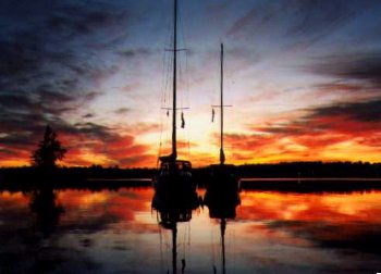 Photo # 1. A spectacular sunset in Pontiac Bay.
 |
The various anchorages in Pontiac Bay add a whole new dimension to cruising
on the Ottawa River between Lake Deschenes and the Chats Falls Dam. The bay is
located well past Quyon on the Quebec side of the river in an area just before
the Chats Falls Dam.
Pontiac Bay is relatively secluded and has the potential to rival Mohr Island as the premier anchorage on this part of the Ottawa River (and almost as many mosquitoes).
It's numerous anchorages can offer protection from winds in a variety of directions, and, with the notable exception of Cadenza Cove, they have mud bottoms. Boats have to use moorings at Cadenza Cove because the bottom of this anchorage is almost all bare rock.
The south side of Pontiac Bay provides for anchorages which are as isolated and
picturesque as parts of Georgian Bay. Onshore, this area of the bay offers some
great hiking opportunities, especially for anyone interested in climbing the
hill to take a closer look at the dam, dykes, and control gates. (Keep an eye
out for poison ivy when hiking in the wooded areas.)
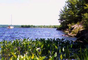 Photo # 2. The view from the southwest corner of the bay.
 |
In recent years the solitary nature of the area has been affected by the fact that more boats are finding their way into the bay and by the operation of a Tim Horton Youth Camp on Pontiac's north-west shoreline. Despite these developments, the bay still has an abundance of wildlife and retains its rustic beauty. In fact, it is possible to see deer at the water's edge in Pontiac Bay early in the morning.
It is unfortunate that a number of under water obstacles make navigating
into Pontiac Bay a chancy proposition. To help overcome this problem, a loosely knit group of individuals styling themselves the "Friends of Pontiac Bay Coterie" have installed private buoys to help mark the twisting and tortuous channel into the bay. These buoys are BBQ propane tanks painted green or red, and they may not be visible until one is almost in the bay (and the red and green paint may be a little faded). It should also be stressed that several seasons of winter ice will cause some of these buoys to move from their assigned locations, although there are periodic efforts to reposition the wayward markers. (Note that navigating into Pontiac Bay can very difficult. Scroll down the page for a map and more information about navigating into this bay.)
Although Pontiac Bay is difficult to get into, it appears to have been more
navigable in the days before construction of the dam. In the 1800's, steam
boats measuring a hundred feet or more in length would routinely make their
way into the southwest corner of Pontiac Bay to deposit passengers travelling
further up river. Here people would make their way around the Chats Falls on
the "horse railway", which consisted of an open coach pulled by two horses
over approximately three and half miles of track. At the other end of the
railway people boarded another steam boat to continue their journey up the
Ottawa valley.
Photo # 1 shows a spectacular sunset which can be enjoyed in anchorages on
the west side of Pontiac Bay. Photo # 2 shows the view from the southwest
corner of Pontiac Bay (Chuck's Notch looking towards Cadenza Cove). This photo
was taken from the spot where one would go ashore to see the rock-cut pictured below.
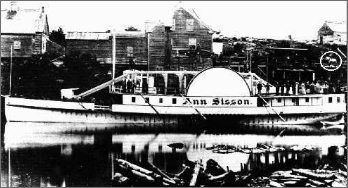 Photo # 3. Paddle wheeler S.S. Ann Sisson.
 |
Photo # 3 shows the paddle wheeler S.S. Ann Sisson at a wharf in Pontiac Bay sometime around the 1870's. This is where passengers would disembark to take the "horse railway". Note the circle on the right of the photography highlighting one of the horses used to pull small passenger cars on the railroad. Also noteworthy is the fact that the horse railway began operating in 1847 at a time when there was a total of only 66 miles of track in all of Canada.
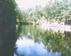 Photo # 4. The Rock-cut - a very short canal.
 |
Photo # 4 shows the rock-cut can be seen by going ashore in the extreme southwest corner of Pontiac Bay. It's all that remains of an early effort to construct a canal around the Chats Falls and eventually open up a navigable waterway from the Ottawa River to Georgian Bay. Work on this rock cut took place between 1854 and 1856 and was abandoned once people realized that excavation methods of the day were no match for solid precambrian rock. Almost half a million dollars was spent excavating a few hundred feet of what was supposed to be a three mile canal.
WARNING!
Anyone navigating into Pontiac Bay does so entirely at their own
risk. People making use of the private buoys and information about navigating
into Pontiac Bay do so at their own risk. There are a number of areas in the bay
where boats can easily go aground and get stuck.
( Note that the map showing the private markers (that was provided
without liability for information purposes) by a group calling themselves "Friends of Pontiac Bay Coterie"
is now seriously out of date. Many of the private marks have moved or disappeared because of
winter ice over the past couple of years. This map is no longer available on this web site.)
NOTE:
The following two stories may help people assess their preparedness for
navigating into Pontiac Bay.
Story One: A few years ago the water level of the Ottawa River was
extremely low. On our way up river to Pontiac Bay we noticed islands and
evidence of shoals that we never knew existed. Since low water conditions make
it even more difficult to safely navigate into Pontiac Bay, we didn't expect to
see any large sailboats in its various anchorages. We were not worried because,
at the time, we were sailing a MacGregor 25 with a swing keel. We made it into
Pontiac, and as we rounded the bend to head into "Cadenza Cove", we spotted a Laser
28 tied to one of the moorings. A Laser 28 draws 5 feet, so we asked the skipper
if he encountered any problems getting into Pontiac. "No problem at all" came the
reply. The next day we saw three large sailboats (in the 30 to 35 foot range)
motoring into Cadenza Cove without any trouble. Moral of this story: if you
know what you are doing, and are familiar with Pontiac Bay, its underwater hazards
are less formidable than they first appear (although one should not become
overly confident).
Story Two: I have heard stories of people trying to make their way into
Pontiac Bay for the first time. They are often equipped with a map showing the
location of private markers, but they lack experience dealing with unfamiliar
waters or navigating around shoals in close quarters. They make it into the bay
but quickly lose track of a couple of the private buoys and touch bottom, or even go aground (easy
to do on a first trip in). They are nervous and become frustrated. They decide to
turn around and head out only to discover that they have also lost track of the
channel leading back to the Ottawa River. They feel trapped in an underwater maze. They
eventually make it out, but not before cursing the map and anyone who has ever
recommended Pontiac Bay as a worthwhile destination. Moral of this story:
Pontiac Bay isn't for everyone.
|
Text and photos by Michael McGoldrick.
[ Copyright & Disclaimer ]
[ Return to Home Page ]
[ Sailquest.com ]
|
|

