Chats Falls Dam
|
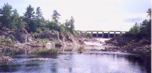 Photo # 1. Control gates at the Chats Falls Dam.
 |
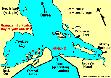
Prior to the construction of the dam and power generating station, the Chats Falls accommodated a 35 foot drop in the river, and consisted of a series of chutes running from what is now the eastern end of the dam all the way to the western-most corner of Pontiac Bay. In their natural state the Chats Falls were quite a tourist attraction. In the years leading up to World War One it was fairly common to see large steam boats (paddle wheelers) heading up river with their decks full of sightseers.
Needless to say, the Chats Falls were obliterated by the dam which was completed in 1932. The dam's generating station has a capacity of 224,000 horsepower, and it is interesting to note that the combined capacity of all the power generating stations along the entire length of the Ottawa River (including its tributaries) exceeds 4 million horsepower.
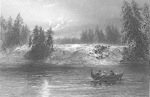 The Chats Falls - steel engraving by W.H. Bartlett, 1840.
 |
Although not as picturesque as the original falls, the dam and it facilities are still interesting to visit. Crews of boats anchored in the southeast corner of Pontiac Bay often climb the hill to get a first hand look of the control gate, spill ways, and the dykes on the western side of the dam. However, people using this route to get to the structure will find that it is a challenge to get a look on the other side of the dam, as demonstrated by the inset in photo # 2. (Although it may not be evident from the photo, I was precariously balanced on top a 10 foot post when I finally got to look over the dyke.) By going ashore in the southwest corner of Pontiac Bay (near the rock-cut), it is possible to get on the dyke. People can then walk along the top of the dyke towards the control gates for a commanding view overlooking the Ottawa River below the dam.
Dangerous Waters Around the Chats Falls Dam
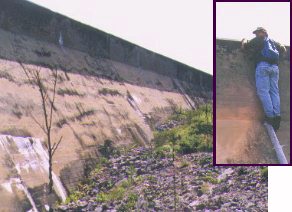 Photo # 2. Dyke on the west side of the Dam.
Inset: Author of this web site looks on the other side. |
The Chats Falls Dam can also pose a danger to boats exploring this end of
the River. Obviously, boats should not go anywhere near the base of the dam in
front of the generating station where there can be severe turbulence and strong undertows. Generally,
boats entering or leaving Pontiac Bay will not come close enough to the dam
to be at serious risk. Nevertheless, very strong currents can quickly develop
when the control gates are releasing large quantities of water from the reservoir.
The danger appears to be greatest for boats passing in the vicinity south-west
of Alexandra Island. There has been at least one report of a 30 foot sailboat
suffering serious damage when caught by such a current and driven onto rocks on
Alexandra Island.
The dam can also play funny tricks on the water level on this end of the
Ottawa River. Because it is so close, any significant fluctuation in the amount
of water being released by the dam can change the water level by as much as a
12 to 15 inches overnight. The same changes may only translate into a difference of a couple of inches over a 24 hour period further down river. Anyone navigating into
very thin water to reach a favourite anchorage may want to consider how they would get out if the water level was to drop a foot overnight.
Obviously, the Chats Falls Dam represents the end of the line
when cruising this stretch of water. From here it is a matter of heading back
to one's home base, which, more often than not, is one the major marinas/yacht
clubs in the eastern end of this part of the river. It is a 44 kilometre ( 27 mile) trip back to
eastern side of Lake Deschenes.
Text, colour photos, and map by Michael McGoldrick.
[ Copyright & Disclaimer ]
[ Return to Home Page ]
[ Sailquest.com ]
|
|