 Baskin's Beach ( & towards Constance Bay )
|
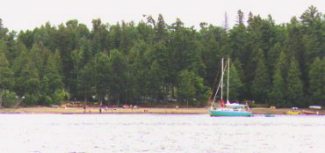 Baskin's Beach.
 |
Baskin's Beach is almost next door to the Port-of-Call Marina and is located just south of Twelve Mile Island. It provides for an indent along the Ontario shoreline which can be used as an overnight anchorage on those occasions when the wind may be blowing from the south or south-east. Onshore, the Britannia Yacht Club maintains a park for the use of its members for camping and picnics.
Boats continuing upriver will pass on the south side of Twelve Mile Island and head toward the buoys which
mark the approach to Constance Bay. However, this can be a little tricky because there are shoals on both
sides of this part of the Ottawa River, and the buoys can sometimes be hard to spot. Fortunately, there is a set of range markers on shore at Baskin's Beach to help boaters negotiate these waters.
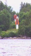 The 2 range markers.
 |
For sailors who may not be familiar with range markers, they should look back at the shoreline next to Baskin's Beach once they are a little past Twelve Mile Island. A fairly large red range marker should not be too difficult to spot. There is a second marker at a slightly higher elevation in the background, but it may be obstructed from view on a boat that is not on the right heading. People may
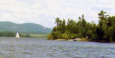 Looking
east from Baskin's Beach.
Looking
east from Baskin's Beach. |
find it necessary to alter their heading to one side or the other until the second marker comes into view. Lining up the lower and higher markers over one another will indicate a safe heading for sailing through this part of the Ottawa River towards Constance Bay.
Text and photos by Michael McGoldrick.
[ Copyright & Disclaimer ]
[ Return to Home Page ]
[ Sailquest.com ]
|
|
