|
Sailing the Lower Ottawa River
|
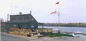 Rockcliffe Yacht Club.
 |
by Michael Lukyniuk
For nearly one hundred years, the Ottawa-Outaouais community relied on
the Lower Ottawa River for its link to the outside world. Steam navigation
on the river began as early as 1822 between Grenville and Hull, which
proved essential for the construction of the lumberyards of Philomen
Wright, and for the construction of the Rideau Canal by Colonel John By
from 1826 to 1832. With the completion of the Carillon Canal in 1834,
navigation was further enhanced.
By 1842, the first regular passenger service was initiated between
Montreal and Hull-Bytown employing a stagecoach in the Montreal-Lachine
portion of the trip, a steamer in the Lachine-Grenville portion, another
coach parallel to the Carillon canal, and a final steamer in the 60 mile
stretch from Carillon to Hull-Bytown. When Queen Victoria chose Bytown to
be the capital of the Province of Canada in 1857, the river once again
served bravely in the construction of the majestic parliament buildings
which were completed in 1866, and in the subsequent growth of the little
community. Throughout the early years of Confederation, the elected
representatives of the new Canadian federation made their way to the
capital on steamers; Sir John A. Macdonald, Canada's first prime minister,
is said to have had a permanent stateroom on one of them!
During this era, the quality of steamboat travel can be best described
as luxurious. For many years it had little competition from the newly
introduced railway service. In The Private Capital, Sandra Gwyn writes "If
travel by rail was a miserable purgatory of dirty, jolting coaches,
constant derailments, and cinders in the eye, travel by steamboat aboard
the Prince of Wales, the Queen Victoria, and later the magnificent
iron-hulled Peerless which could accommodate a thousand passengers, offered
a mode of transportation that was as enjoyable as it was efficient." By
1910, the railway overtook the passenger steamboat service; steamboat
excursions continued until the mid-1920s, but the primary use of the river
thereafter would be limited to freight.
A Guided Tour...
We'll begin our cruise of the Lower Ottawa (in the section from the
Chaudire Falls to Upper Duck Island) at the foot of the historic Rideau
Canal. At this point, your boat sits below the locks which transport river
traffic to and from the Rideau Canal. The world renown Chateau Laurier is
on the eastern side and the East Block of the Parliament Buildings faces
it. Heading west from the locks along the base of the escarpment below the
Parliament Buildings, you pass below the neo-gothic structures of the
Library of Parliament, the Centre Block, and the West Block, followed by
the Confederation Buildings, the Federal Court, the Supreme Court, and the
National Archives and Library. The river does exhibit some man-made
turbulence between the Supreme Court and the National Archives due to
underwater pipes which come from a central heating plant nearby.
Not far away, you are prevented from travelling any further upriver
because of the Portage Bridge and the Chaudiere Falls. A small picturesque
bay formed between Richmond's Landing and Victoria Island has been used by
some boaters as an overnight anchorage. The miniature peninsula known as
Richmond's Landing used to be the site where settlers would unload their
cargo and haul it along the road leading to the village of Richmond,
Ontario, some twenty miles distance. Victoria Island was for a long time
the site of a large lumbermill which dispatched immense rafts of timber as
far away as Europe. There is an old abandoned stone building on the site
which was used in the lumber business. Strange as it may seem, this
tranquil site lies near the heart of the bustling city but feels as though
it is nestled far away near some rustic community.
Heading Down River
Turning around and heading down river, we pass a small low lying
seagull-ridden island known as Hull Island (although I must confess that
for several years, I thought it was appropriately called "Gull Island").
The river is very shallow at this point. Hull Island divides the river;
if you swing upriver in the north channel, you will head near the naturally
very turbulent Chaudiere Falls. I confess that I have never ventured there,
preferring to leave it to the small sea-dos which revel in the rough
waters. Heading down river from Hull Island, the river deepens. On the
north shore across from the Rideau Locks, you will find the twin curved
structures of the Canadian Museum of Civilization and its small private
dock holding a large West Coast Haida canoe as well as a Durham boat.
Proceeding under the Alexandria Bridge (constructed in 1900 and initially
used for railway and automobile traffic), you will notice the Hull Marina
on the north shore which is home to many sail and power boats. There is a
good launching ramp here and ample parking for those who would like to
trailer sail. It is also a popular place for a large number of tourists
who embark on cruise boats like the Sea Prince II or the Paula-D.
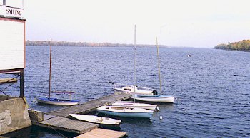 The view downriver from the New Edinburgh Club (ONEC).
 |
Along the north shore, parklands stretch for a couple of miles from
the marina to the mouth of the Gatineau River. This wasn't always the
case, however. An impressive cement plant was once located along that
shoreline as well as lumber mills. The natural beauty of this area was
always striking. During the 1940s, the British High Commissioner to Canada
used to paddle across the river from his nearby residence known as
Earnscliffe, to bird watch in a cove where Brewery Creek meets the Ottawa
River. He reported on a large variety of birds which were not normally
found in the environs.
Along the south shore next to the Alexandria Bridge, you can't miss
the towering Nepean Point topped with the statute of explorer Samuel de
Champlain holding his legendary astrolabe. Champlain explored this region
as early as 1613 by canoe and lost his brass astrolabe (a device for taking
measurements of latitudes) while on a portage near Cobden, Ontario; it was
discovered in 1867 by a 14-year old farm boy and is now part of the
Civilization Museum's collection. Behind Nepean Point is found the glass
menagerie known as the National Art Gallery designed by Moshe Safdie. Next
to the Art Gallery is found another interesting structure which looks like
a castle, the Royal Canadian Mint. The Ontario shoreline also contains a
couple of interesting-looking turn of the century boat houses. Some rowing
clubs are based here, as well as the cruise ship The Senator which conducts
excursions to Montebello on Sundays.
The six lane Macdonald-Cartier Bridge crosses the river at this point.
To the east of the bridge lies the previously-mentioned Earnscliffe, a
gabled mansion where Sir John A. Macdonald lived from 1871 to his death in
1894. It is now the official residence of the British High Commissioner to
Canada. A couple of interesting buildings can be seen next to Earnscliffe;
the distinguished National Research Council building overlooks the river,
and behind it is found the ultramodern Lester B. Pearson Building, home to
the Department of External Affairs.
Where Rivers Meet - the Rideau & Gatineau Rivers
One of the most impressive natural sites on this part of the river is
undoubtedly the Rideau Falls, a greenish cascade of water which acts as a
curtain for the brave souls who would dare to walk under them. It was
Champlain who christened the falls after the Algonquin Indians took him on
a walk underneath. A favourite game of cruise boats is to poke their bows
into the shower of the falls to the delight of the tourists. The falls are
divided in two by Green Island which houses the newly renovated Ottawa City
Hall complete with pyramids and towers, designed once again by Moshe
Safdie. Next to the falls, we can see the French Embassy, and the
official residence of the Canadian prime minister (a former lumber baron's
mansion).
Below the prime minister's residence is an area known as Governor's
Bay, a shallow and weedy part of the river. High on the eastern side of
the bay is an old gazebo. From this lookout, sightseers can have a
breathtaking view of the Ottawa and Gatineau Rivers as well as the bluish
Gatineau Hills in the background. Boaters can replenish their gas tanks or
have a meal at the Rockliffe Boat House which is located just below the
lookout. A lot of powerboats and houseboats are moored for the season at
this spot.
Across from this site lies the mouth of the lengthy Gatineau River
which reaches far into the Canadian Shield. On the western shore, the
river bed is shallow and very weedy. On my first experience in motoring up
the Gatineau from the western approach, my keelboat came to a complete halt
held back by the dense underwater weeds; luckily, I had a retractable keel
and was able to pull myself out of this embarrassing situation. On the
eastern shore we find the community of Pointe Gatineau with its Quai des
artistes, a spot where you could tie up for a spell and have a meal at a
nearby restaurant. (In fact, one of the best French cuisine restaurants in
the entire metro region, L'Eau Vive, is located within a short walk of the
quay.) The bridge which crosses the Gatineau River next to the quay is
called the Lady Aberdeen Bridge, named after the wife of a former Governor
General and founder of the Victoria Order of Nurses who almost lost her
life in 1896 when she fell through the ice in the not-so-frozen river along
the Quebec side. The towns folk generously came to her aid and
commemorated the event by naming the bridge after the thankful victim. The
park across from the quay is called Parc Lemay; it has several bike paths
and a modest swimming beach. Archaeologists have uncovered the remains of
an Indian settlement there dating from the time of Christ.
Heading down river, you will notice a lot of small docks with
different types of boats and a good number of bars and restaurants. Around
the end of August each year things become very busy when the international
hot air balloon festival is held here. Some seventy balloons ascend twice
daily during the event, and one of the best places to watch it is right on
the river!
The Ottawa River broadens at this point and is a popular site for
small boat sailing. Two clubs are located on the Ontario side of the river
in an impressive building sitting on the water and dating back to 1883.
The Ottawa New Edinburgh Club (ONEC) is the owner of the building and
shares space with another club, RA Sail. The fleets of the two clubs
consist of lasers, albacores, and mistrals which are used for training and
racing. There are some larger sailboats moored at ONEC belonging to
private members.
The River Around Kettle Island
To the east of this lies Kettle Island, a good sized island stretching
for about a mile down the river. Towards the north side, the river is
filled with underwater weeds, so traffic flows down the south side of the
river. This uninhabited island is now owned entirely by the City of
Gatineau and is home to a variety of birds: blue herons, kingfishers, and
different types of ducks. A few boaters may be seen camping overnight on
the island next to its shallow shoreline.
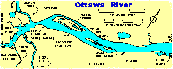
The Rockliffe Yacht Club lies across from the mid-point of the Island
on the Ontario side. It boasts a large number of sailboats and a small
clubhouse. Behind it lies the National Museum of Aviation; on a good day
you may see its white biplane taking off and landing.
As we approach the eastern extremity of Kettle Island, we can swing
around and enter the north channel. It is well marked with buoys and leads
you to the Kitchissippi Marina in Gatineau. Next to the marina you will
find a handy restaurant and a local baseball diamond. The boats moored
here tend to be mostly powerboats and houseboats. Returning back to the
main channel along the Quebec side, you will be following Rue Hurtubise
with its collection of fine looking houses.
The end of our excursion takes us into another broad stretch of the
river bordered by Kettle Island, the Quebec shoreline and Upper Duck
Island. For some inexplicable reason, the wind tends to shift frequently
in this area. Keel boats should be cautious of the Upper Duck Island
shoreline; the sandy river bed is surprisingly shallow for a good distance.
This is once again a popular spot for boaters wishing to anchor overnight
or go for a swim.
From the Chaudiere to Upper Duck, the Ottawa River bustles with
activity. On certain dates, like July 1st when boaters congregate below
Nepean Point to watch the Canada Day fireworks display, this part of the
river might even be described as a place to avoid! From my experience,
however, the river always holds something of interest, whether that may be
a hot air balloon attempting to perform a "baptism" on the water, or a
friendly sailboat race running from the Hull Marina to Kettle Island. It's
natural beauty and historical background make sailing the Lower Ottawa
River a memorable event.
© Michael Lukyniuk, 1996.
Some Additional Information about Marinas/Clubs
on this part of the Ottawa River.
The New Edinburgh Tennis and Sailing Club is approximately 1 kilometre east of the Rockcliffe Boat House Marina. Three kilometres further east there is the Rockcliffe Yacht Club (RYC). This club has approximately 100 members, both
sailors and power boaters in about a 50/50 mix. The RYC offers overnight docking or mooring at rates similar to those for docking overnight at the locks on the Rideau system. Reciprocal arrangements with some other yacht clubs in the "Golden Triangle" (Ottawa-Kingston-Montreal) area generally provide for one free night if you are a member of one of those clubs. The RYC has pumpout facilities, water, ice, and restrooms with showers. The club has a very good launch ramp (concrete descends about 50 feet into the water) and day launching
is available at a reasonable fee. In addition, the club has 24 hour security which is ideal for those wishing to leave their boat overnight and visit the sights in downtown Ottawa.
There are also two marinas on the Quebec side of the river in this area.
One is located just behind the eastern tip of Kettle Island in the narrow channel there (most likely a municipal facility). It offers fuel, pumpout, and has a small restaurant. The other marina is located about 2 kilometres east of Lower Duck Island. It sells fuel, has a pumpout facility and offers winter storage for fairly large boats.
Information provided by Dave Rodger (May, 1996)
Some Additional Information on
Cruising the Lower Ottawa River.
- There are a few masting facilities on the Ottawa
River for boats going in or out the Rideau system.
There is a good masting crane at the Hull marina (819-595-7390),
but tying up is difficult because of the concrete
wall and the area gets rocked a lot by the wave
action of the many powerboats going by. There is
also a good one at the Rockcliffe Yacht Club (RYC),
but boats are limited to a draft of 5 feet or
less to get in.
- Chris Locke and Tom Robertson sailed downriver from Ottawa to the
Carillon Lock in a Tanzer 16 during the summer of 1999. Here's a link to
a photo essay of their cruise (it's worth checking out):
http://www.clal.ca/boat99/
- The total waterway distance between the Hull Marina and the locks at
Ste-Anne-de-Bellevue is close to 150 Kilometres (90 miles). Montebello is
approximately 65 Kilometres (40 miles) down river, and it's another a 50
kilometres (30 miles) to the Carillon Lock. Once through the lock, the
Ottawa River soon expands into the Lake of Two Mountains. From Carillon it's a 30 kilometres (18 miles) hop to the lock at Ste-Anne-de-Bellevue. The lower part of
the river is covered by chart 1515 (Papineauville to Ottawa) and chart 1514
(Carillon to Papineauville).
- The Rockcliffe Boathouse Marina is the first such facility east of the
Rideau Falls (5 km east of the Parliament Buildings). It offers overnight
moorings, pump out, restrooms and showers. You can contact this marina on
VHF, channel 68, or by calling 613-744-5253.
- There is a marina at Rockland on the Ontario side of the river
approximately 36 kilometres (22 miles) east of Ottawa. They have 120 full
service docks, some of which are available on a daily or weekly basis. They
sell gasoline and offer a pump out service. Their phone number is 613-446-4756.
- The Chateau Montebello has a marina with docks available on a daily or
weekly basis. People on boats staying at this marina have access to some of
the facilities of this ritzy resort. Unfortunately prices for tying up at
Montebello can be a little steep - ranging from $1.70 to $1.90 per foot of
boat length per day (in 1996). For more information call 819-423-5328.
- The Voyageau (Carillon) Ontario Provincial Park is located on the Ottawa River
immediately west of the Carillon Dam. It has boat ramps and a variety of
camping grounds. For more information call 613-674-2825. A link to the Voyageur Park web site.
- The Carillon lock is truly an impressive facility. It is one of the
highest locks in North America. A single locking operation raises or lowers boats across
a 66 foot (20 meters) difference in water levels - the equivalent of 7
stories. It takes around 20 minutes and some 25 million litres of water to
fill the lock. The dam at Carillon is also the largest power generating
station on the Ottawa River. The fee for single lockage at Carillon (in
2001) is $2.95 per metre of boat length (one way). Draft clearance is 9 feet, overhead
clearance is 42 feet, and transit time is 45 minutes. For more information call 514-537-3534. A link to a Parks Canada site about the Carillon Canal
- The lock at Ste-Anne-de-Bellevue serves as the demarcation point
between the Ottawa River and the Saint Lawrence Seaway. Average lockage
time is 15 minutes, total transit time is about 30 minutes, and fees are
set at $2.46 (in 2001) per metre of boat
length (one way). Call 514-457-5546 for more information. A link to a Parks Canada site about the Sainte-Anne-de-Bellevue Canal
Information compiled by Michael McGoldrick (1996)
Website, photos, map and some text by Michael McGoldrick.
[ Copyright & Disclaimer ]
[ Return to Home Page ]
[ Sailquest.com ]
|