|
Dinghy Cruising/Camping on the Ottawa River
|
 The Ottawa River is well suited for dinghy cruising.
 |
A series of strategically located islands in the Ottawa
River between Lake Deschenes and the Chats Falls Dam
suggest that this body of water is ideally suited for
anyone wanting to go cruising in an open dinghy with
overnight camping stops.
Before reading any further, you should know that I have
never cruised the Ottawa River in an open dinghy. The
smallest boat I have sailed up river was a 18.5 foot
Sandpiper, but it has a nice enclosed cabin. (This article
started off as a response to a question on a local newsgroup.) I should also
indicate that while all the islands I will refer to are
completely uninhabited, I do not know whether any of them
are privately owned or if there are any regulations
concerning overnight camping on them. However, from what I
can see, I do not believe that anyone cruising is a small
dinghy would have problems camping on these islands for an
overnight stay.
Aylmer Island
Aylmer Island is an obvious destination for anyone
sailing from the eastern side of Lake Deschenes. Many people
are familiar with it as a handy destination for day outings.
It is a rather nice little island, but anyone romping around
in its underbrush should keep an eye out for poison ivy
(and there can be
 Aylmer Island.
 |
lots poison ivy).
There is something of a spectacular up-river view from the
top of the hill on the back side of island. There is also
evidence that teenagers may use the Aylmer Island for
parties during evenings on weekends, and don't forget that
it is an old Indian burial ground! Whatever the case, the
goings-on at Aylmer Island may be subject to greater
scrutiny by the authorities because of its proximity to the
large urban centres. The island itself falls within what used to be Kanata (now Ottawa).
Twelve Mile Island lies approximately 15 kilometres (9
miles) upriver from Aylmer Island. This is the longest leg
between any two islands on this part of the Ottawa River.
 The docks at Pinhey Point.
 |
If you do make Twelve Mile Island your next destination, you
will pass Pinhey Point at about the half way mark. You may
want to stop at Pinhey Point to have lunch or simply to
visit the heritage site. Being in a small dinghy, you will
be able to tie up at the site's small dock. On shore you
will have access to a nice large public park. Although no
overnight camping is permitted here, the park is equipped
with picnic tables and washrooms. If it is raining (heaven
forbid), you will have the option of eating your lunch under
the cover of the bandstand erected at the site by the City of
Ottawa (but the bandstand cover may not be erected every year).
Twelve Mile Island
When leaving Pinhey Point you will be in easy striking
distance of Twelve Mile Island. It is just a little past the
Port-of-Call Marina. If the river level is high, the
surface area of Twelve Mile Island may not be greater than
that of 40 foot yacht. Nevertheless, it's a real island
complete with a small Coast Guard light house. If you decide
to overnight here, make sure your tent has good mosquito
screens because there is a bit of a marshy area in the
vicinity of the island.
Mohr Island is only 11 kilometres (a little over six
miles) upriver from Twelve Mile Island. Mohr's prominent U-
shape anchorage will soon come into view to anyone
approaching the island from the east. A good spot for
setting up camp may not be immediately obvious because Mohr
is a fairly large Island. In fact, it is actually two
islands - it is divided by a creek which flows into the U-
shaped anchorage. From what I have been able to see, Mohr is
entirely covered by a thick forest and has no paths or large
clearings. I tried to walk through a part of it once, and at
times, I felt like I was cutting my way through the Amazon
Jungle.
Mohr Island
People setting up camp on Mohr for the first time may
want to consider doing so on the wedge of land on the south-
west corner of the U-shaped anchorage. There are a few
small clearings here and I have seen tents set up in this area
on a couple of occasions. Wherever you do set up your tent and
secure your dinghy for an overnight stay, be sure to
calculate for the possibility that the river level may rise
or fall by as much as eight inches if the water flow through
the Chats Falls dam is suddenly increased or decreased. Also
be aware that once the sun goes down, you will be inundated
by mosquitoes. Some boaters have theorized that Mohr Island
is the breeding ground for half the mosquitoes of North
America.
From Mohr Island you will have to travel another 10
kilometres (6 miles) to get to Pontiac Bay. Along the way
you will be able to stop at Quyon. A public park surrounds
the area in the immediate vicinity of the village's small
dock, and supplies are within easy walking distance.
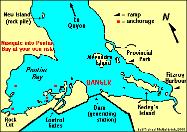
Pontiac Bay
Once in Pontiac Bay you can set up camp on one of the
small islands in the south, south-east corner of the bay. In
fact, most of the southern end of the bay appears to be
public land, although I am not sure of this. On one of the
islands you may come across a tent or two that are being
used by kids from the nearby Tim Horton Youth Camp for
overnight camping trips. When setting up camp in Pontiac Bay,
remember that the river level can fluctuate by as much as a
foot because of the effects of the dam. And like Mohr Island,
mosquitoes will make their presence known the minute the sunsets.
Certain areas of some of these islands come within jumping
distance of the mainland, and you will generally find that
you can move on and off these islands by foot. This can come in
handy because there is lots of room to roam on the south side
of Pontiac Bay, and there are some good hiking opportunities for
anyone who is interested in climbing the hill leading to the top
of the Chats Falls Dam.
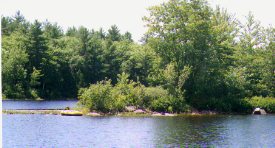 One of the small Island in Pontiac Bay.
 |
Pontiac Bay is full of shallow spots and underwater
obstacles. This is a real concern to keelboats that must
carefully follow a twisting channel into the bay. Obviously,
this is less of a problem for small boats that are able to
pull up their centre boards and kick up their rudders, but
there are rocks in Pontiac that can still catch the bottom
of a dinghy. Small boats may also be exposed to danger in
their approach to this part of the river by strong currents
that may develop if the dam is in the process of releasing
large amounts of water. However these currents should not
present too much of a problem for boats heading directly
into Pontiac, especially if they stay relatively close to
the Quebec side when approaching the mouth of the bay.
Nevertheless, it should be stressed that anyone approaching
and sailing into Pontiac Bay does so entirely at their own risk.
Fitzroy Provincial Park
When sailing this end of the river, you may also be
tempted to stop in at the Fitzroy Provincial Park on the
Ontario side just opposite of Pontiac Bay. The park's small
dock is located roughly between Alexandra and Kedey's
Islands (both of these islands are inhabited).
If you do
decide to head over, be warned that you are almost sure to
encounter the currents from the dam if you cut across the
river between Pontiac Bay and the Fitzroy Provincial Park.
In fact, any boat navigating its way around the south side of
Alexandra Island will likely have to contend with the
effects of the dam. People have reported that these waters
can become quite dangerous if the dam is spilling large
amounts of water. You may be better off avoiding this area
in a small boat unless you are sure of what you are doing
and know what conditions you will be dealing with.
It may be possible to reach Fitzroy Provincial Park
safely by approaching the area from behind Alexandra Island.
This means passing between
Alexandra Island and the Ontario shoreline. I have never attempted
this and do not know if it is feasible. The chart indicates
the water between the island and the mainland is very
shallow ranging from 1 to 4 feet (with some rocks).
I have never put into the Fitzroy Provincial Park by
boat, but I have gone camping there by car. I can report that
it is an attractive park which offers a variety of nice
private camp sites. You may want to phone in advance of any
visit to confirm the procedure for checking into the park by
boat. For more information, call 613-623-5159, or see the Fitzroy Park Web Site.
For more information about dinghy cruising in general, see the "All about Dinghy Cruising" on the Hostellers Sailing Club website.
Text, photos, & maps by Michael McGoldrick.
[ Copyright & Disclaimer ]
[ Return to Home Page ]
[ Sailquest.com ]
|
|